National Environment Agency: From the material analyzed on the basis of satellite data, it is clearly seen that in the valley of the Bubistskali river there was a collapse of a rocky mass with a volume of about 500,000 cubic meters
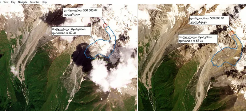
The National Environment Agency distributes satellite images. According to the agency, high-resolution satellite images confirm that there is no evidence of water damming in the valley before the disaster.
At the same time, the National Environment Agency notes that the material analyzed based on satellite data clearly shows that in the valley of the Bubistskali river, to the west of the Buba glacier, a rock mass of about 500,000 cubic meters has collapsed.
"In the first report of the National Environmental Agency, it is clearly stated that before the disaster or during the disaster, there was no damming in the Bubistskali river valley. Specialists of the agency confirmed this with a water level observation station at the confluence of the Bubistskali and Chanchakha rivers. However, in parallel with the preparation of the initial report, our specialists continued to analyze various information, we received high-resolution satellite images, which describe and confirm that there is no evidence of water damming in the valley before the disaster. This once again demonstrates how important it is for experts to assess the issue and then talk to the public.
From the material analyzed on the basis of satellite data, it is clearly seen that in the valley of the Bubistskali river, to the west of the Buba glacier, a rocky mass of about 500,000 cubic meters has collapsed. As a result of the collapse of the rock avalanche, the glacial mass spread over about 62 hectares was broken, which caused the outflow of subglacial waters (additional studies are underway to determine the volume of water). This once again confirms the assessments given in the first report of the National Environment Agency, the complexity of the disaster and the impossibility of predicting it. It is known that due to dependence on many factors of the collapse of rocky and glacial masses, its place and time cannot be accurately determined. It should be noted that according to the data obtained from the meteorological station and the meteorological radar in the valley, no high-intensity precipitations were observed.
For information, the early warning system includes directions for predicting heavy rainfall, hail, strong winds, drought, floods, flash floods. As for the glaciological and rocky processes developed in the valley, as we mentioned above, it is complex in nature and it is impossible to determine the exact time and place of the collapse of rocky and glacial masses," the National Environment Agency reports.